TIMELINE: Oklahoma could see severe storms with hail threat on Saturday
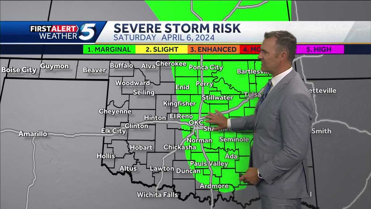
Oklahoma could see another round of severe weather this weekend as part of the state, including the OKC metro, is under a marginal threat of storms. Oklahoma could see severe storms with a hail threat on Saturday, with temperatures expected to reach highs in the 70s, even 80s. The potential for severe weather is low, with a strong storm system expected to move in, but low-level moisture will help keep the threat low. KOCO 5 First Alert chief meteorologist Damon Lane warns that the tornado threat is very low and that while there is a low tornado threat, low moisture is expected to aid in preventing tornadoes from developing. Warning signs include a fire danger in western Oklahoma, which has a fire watch out for the area. Another round of severe weather could be expected this weekend as part of the state, including the OKC metro, is under a marginal threat of storms.
Publié : il y a un mois par Jonathan Conder, https://www.facebook.com/MeteorologistJonathanConder dans Weather
HIGHS IN THE 70S, EVEN 80S. OKAY, A LITTLE BIT BREEZY. WHAT DO YOU NEED TO KNOW? IT’S WINDY SATURDAY. STORMS ARE COMING IN LATE. THE RISK IS LOW. DO YOU NEED TO WORRY ABOUT IT? NO. YOU SHOULD PAY ATTENTION. IT INCLUDES OKC ABOUT 7 TO 10 P.M. IT’S ABOUT THE WINDOW THAT WE’D SEE STORMS GO UP OR MOVE THROUGH HAIL AND WIND RISK. BUT ISOLATED SEVERE. MOST OF US WILL BE JUST FINE. I KNOW THERE’S A LOT OF OUTDOOR ACTIVITIES. UM, JUST, YOU KNOW, HAVE YOUR KOCO APP AND, UH, YOU GUYS GET THE UPDATED FORECAST AND WE IT’S NOT LIKE A MODEL DRIVE WE PUT IN OUR FORECAST INTO THAT. SO WHEN YOU’RE LOOKING AT THOSE NUMBERS THAT’S THAT’S OUR FORECAST. IT’S NOT JUST SOME COMPUTER DOING IT OKAY. NOW WHEN IT COMES TO WESTERN OKLAHOMA SATURDAY WATCH OUT. FIRE DANGER IS REAL BAD. THEY ACTUALLY HAVE A FIRE WATCH ALREADY. LET’S TALK ABOUT THE ECLIPSE. THERE IS A RISK OF CLOUD COVER AND THIS IS WHAT’S GOING TO BREAK IT DOWN WHEN TOTALITY IS HAPPENING. I PAUSE IT AT 130. IT’S REALLY AT 147. OKAY. AND THERE’S A PATH OF TOTALITY. SO YOU GOT TO BE EAST. REALLY EAST OF ANTLERS AND NEAR IDABEL. AND THIS IS GOING TO BE GREAT. BUT TEXAS AIN’T LOOKING GOOD. WORST CHANCE OF CLOUD COVER. BEST CHANCE OF A CLEAR SKIES, ACTUALLY, MISSOURI AND ARKANSAS. OKLAHOMA. THERE’S A CHANCE THAT WE COULD GET COVERED UP. WE’LL SEE. YESTERDAY, THE DAY BEFORE, I WAS LIKE, WE’RE IT’S RUINED. BUT NOW I’M LIKE, HUH? THERE’S A CHANCE CLOUDS MIGHT BREAK. BY THE WAY, IF YOU’RE GOING TO BE DOWN THERE LATE IN THE DAY, IN THE EVENING STORMS FIRE. THAT’S A WARM FRONT. THOSE ARE HAILERS. THERE’S A RISK. LEVEL TWO. SO ON YOUR DRIVE HOME COULD BE A LITTLE STORMY. PLAN. REALLY? A LONG LINES, A LOT OF TRAFFIC ON THE DRIVE HOME. OKAY. RAIN TUESDAY, WEDNESDAY AND THEN NEXT WEEK. IT LOOKS REALLY NICE
TIMELINE: Severe storms with threat of hail possible Saturday in Oklahoma The threat is for hail and wind, and there could be isolated severe thunderstorms Oklahoma could see another round of severe weather this weekend as part of the state, including the OKC metro, is under a marginal threat of storms.>> KOCO weather page | Get KOCO on the goKOCO 5 meteorologist Jonathan Conder says Saturday will be windy, and there's a chance for storms later in the day and evening. The risk is low, being a level-one marginal threat as of Thursday afternoon.The risk is for north-central Oklahoma down through the OKC metro, down to Ardmore and in eastern Oklahoma. The threat is for hail and wind, and there could be isolated severe thunderstorms. KOCO 5 First Alert chief meteorologist Damon Lane added that the tornado threat is very low. A strong storm system will move in, but low-level moisture will be lacking – which will help keep the threat low.Damon says if storms do develop, they'll do so between 5 p.m. and midnight. Be sure to download the KOCO 5 app to receive customized weather alerts. You can watch our team coverage on the app, too.>> Check Closings>> Check Live, Interactive Radar>> Watch KOCO 5 Coverage>> Download the KOCO 5 app on iPhone>> Download the KOCO 5 app on Android>> "Like" KOCO 5 on Facebook>> "Follow" KOCO 5 on X Oklahoma could see another round of severe weather this weekend as part of the state, including the OKC metro, is under a marginal threat of storms. >> KOCO weather page | Get KOCO on the go KOCO 5 meteorologist Jonathan Conder says Saturday will be windy, and there's a chance for storms later in the day and evening. The risk is low, being a level-one marginal threat as of Thursday afternoon. The risk is for north-central Oklahoma down through the OKC metro, down to Ardmore and in eastern Oklahoma. The threat is for hail and wind, and there could be isolated severe thunderstorms. This content is imported from Facebook. You may be able to find the same content in another format, or you may be able to find more information, at their web site. KOCO 5 First Alert chief meteorologist Damon Lane added that the tornado threat is very low. A strong storm system will move in, but low-level moisture will be lacking – which will help keep the threat low. Damon says if storms do develop, they'll do so between 5 p.m. and midnight. Be sure to download the KOCO 5 app to receive customized weather alerts. You can watch our team coverage on the app, too.